Underwater 3D modelling
Photogrammetry is a powerful image processing method that utilizes numerous photographs taken around an object or setting, encompassing various viewpoints. By meticulously processing these photographs, it produces an accurate and detailed 3D model, offering a comprehensive representation of the original subject.
Underwater photogrammetry is an even more specialized field as the underwater environment introduces several, quite unique, challenges to the execution and accuracy of the method. Underwater photogrammetry has become one of the most widely adopted methods for documenting and reconstructing submerged objects and settings for various commercial, scientific, and research purposes.
BM has the equipment and the technology to produce detailed underwater 3D photogrammetric models and provide solutions well-suited for the Maritime industry, the effective conduct of marine incident investigations, the support of the archeological-underwater cultural heritage (UCH) research with inexpensive and non-destructive means of documentation, and the assistance of environmental research and monitoring.
BM modeling project : 3D model of a Piper airplane wreck constructed out of photogrammetric processing of 5,000 UHD images captured by our ROVs. The end result is a highly detailed and accurate representation of the wreck, capturing even the smallest features and nuances.
Our team utilizes state-of-the-art technology and expertise to reconstruct every aspect of the modeled subjects faithfully. The 3D models we deliver serve as valuable tools for researchers and archaeologists and provide a captivating visual experience for anyone interested in exploring the underwater world.
Our 3D models can enhance the inspection efficiency of port structures, vessels, quays, mooring chains, bridge piers and foundations, water tanks, offshore wind farms, and other underwater structures. Through this capability, BM can provide precise and reliable information to support various underwater assets' maintenance and inspection needs.


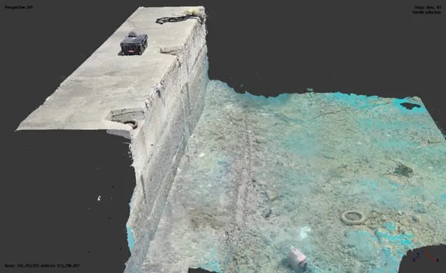
BM modeling project: Modeling of the pier footing scour zone in a major multi-span cable-stayed bridge. By utilizing underwater photogrammetry, detailed and accurate measurements of the scour zone were obtained. This modeling project involved capturing tens of thousands of 24MP resolution photos of the scour zone area from various angles and positions. The images were then processed using specialized software to reconstruct a three-dimensional representation of the scour zone at mm-level accuracy.

BM modeling project : 3D model of the underwater lightning protection system in a major multi-span cable-stayed bridge. This model provides accurate visualization and measurements for the inspection and analysis of the lightning protection system enabling the clients engineers to access the structure easily and effectively.

BM modeling project: 3D model of a multi-span cable-stayed bridge's pier cone. This model was created using thousands of 27MP resolution photos resulting in an ultra-high resolution model with mm-level accuracy.

BM modeling project: BM was assigned the task of locating and retrieving an anchor along with two lengths of chain that had become lost in a complicated rocky seabed in the Aegean Sea. To search for, detect, and determine the geolocation of the anchor and chain, an ROV equipped with advanced detection sensors (including Multibeam Imaging Sonar and UHD cameras) and navigation equipment (USBL and DVL) was utilized. A 3D model of the anchor and chain layout on the intricate rocky terrain was developed to aid our divers in executing a successful salvage plan.
Why Choose 3D Modelling
In the demanding world of subsea inspections, 3D modelling technology is redefining industry standards, offering transformative advantages over traditional video-based General Visual Inspections (GVI) and Detailed Visual Inspections (DVI).
Unmatched Visualization
With 3D modeling, inspectors can explore underwater structures in a fully interactive, three-dimensional space. This dynamic approach provides a crystal-clear understanding of the environment, uncovering intricate details often missed in flat, two-dimensional video footage.
Access Hard-to-Reach Areas
The power of 3D models lies in their ability to be manipulated from any angle, allowing experts to view complex subsea structures from perspectives that traditional inspections simply can’t achieve. This capability is invaluable in identifying hidden issues and improving decision-making in challenging underwater conditions.
Precision You Can Rely On
3D models deliver an unparalleled level of accuracy, enabling precise measurements and detailed analyses of critical underwater assets. This precision is key to effective maintenance planning and safeguarding structural integrity.
Smarter, More Efficient Maintenance
When paired with advanced data analytics and artificial intelligence, 3D modeling becomes a game-changer for predictive maintenance. By identifying potential issues early, it helps streamline operations, improve efficiency, and minimize costly downtime.
The Future of Subsea Inspections
From enhanced visualization to unmatched precision and smarter maintenance solutions, 3D modelling is leading the charge in revolutionizing subsea inspections. It’s not just an upgrade; it’s a superior solution for tackling the complexities of underwater environments.
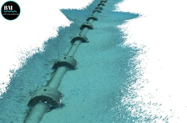


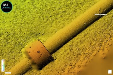

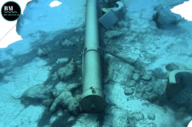
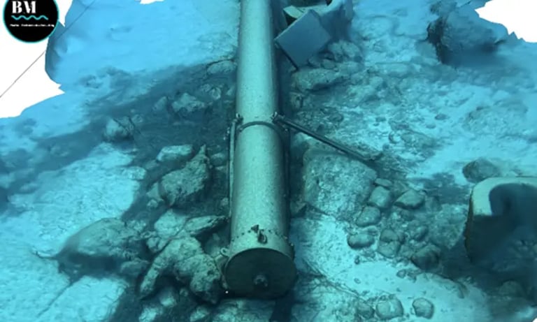

Underwater Oil Pipeline - 3D Photogrammetric Model Point Cloud
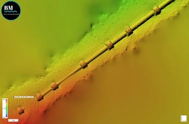
Underwater Oil Pipeline - Georeferenced Digital Elevation Model [DEM]
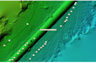
Underwater Oil Pipeline - Digital Elevation Model [DEM] overlay on GIS
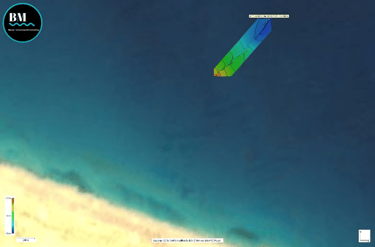
Underwater Oil Pipeline - 3D Photogrammetric Textured Model
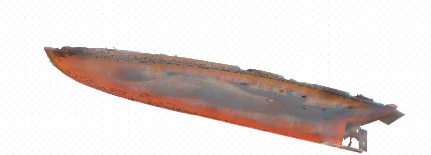
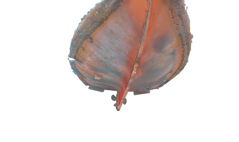
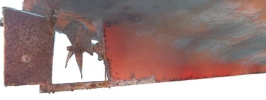
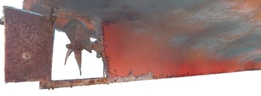
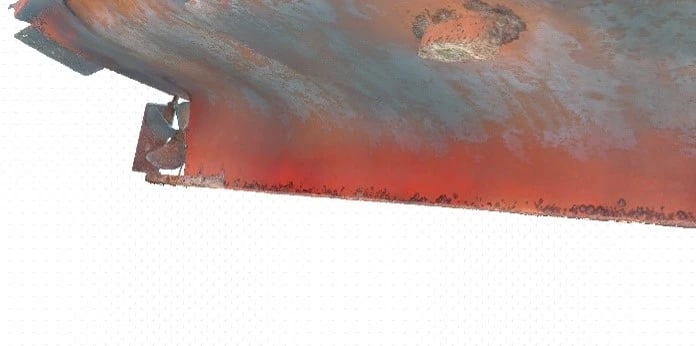
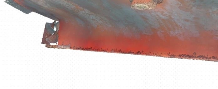
Ship Hull, Propeller & Rudder Inspection - 3D Photogrammetric model
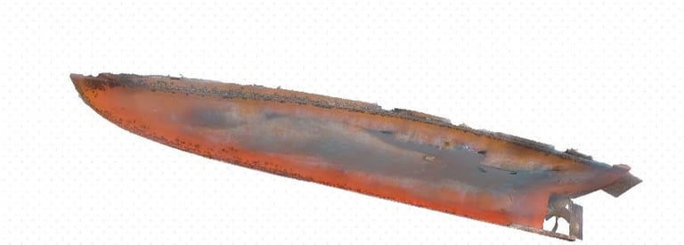
Ship Hull, Propeller & Rudder Inspection - 3D Photogrammetric model
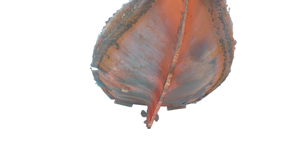
Ship Hull, Propeller & Rudder Inspection - 3D Photogrammetric model
Ship Hull, Propeller & Rudder Inspection - 3D Photogrammetric model
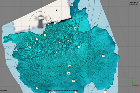
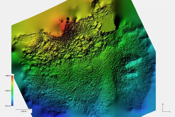
Port Entrance Bathymetry - Georeferenced Digital Elevation Model [DEM]
Port Entrance Bathymetry - Digital Elevation Model [DEM] for bathymetric survey and scour condition assessment
Underwater Oil Pipeline - Digital Elevation Model [DEM]
Underwater Oil Pipeline - Digital Elevation Model [DEM]
Combined Aerial & Underwater Port Model - 3D Georeferenced Model for Seabed & Quay Wall Assessment
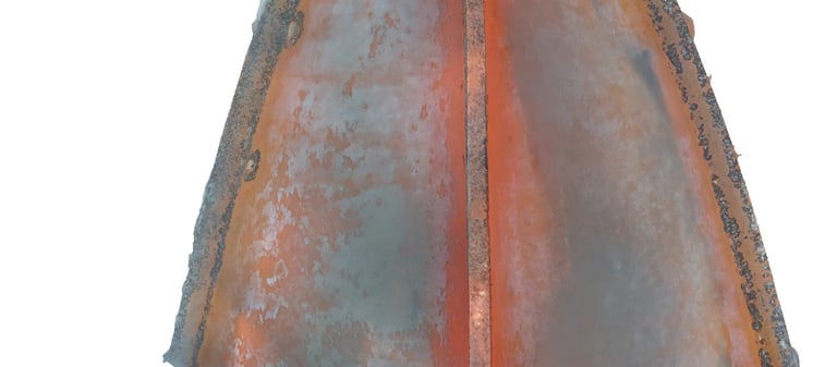
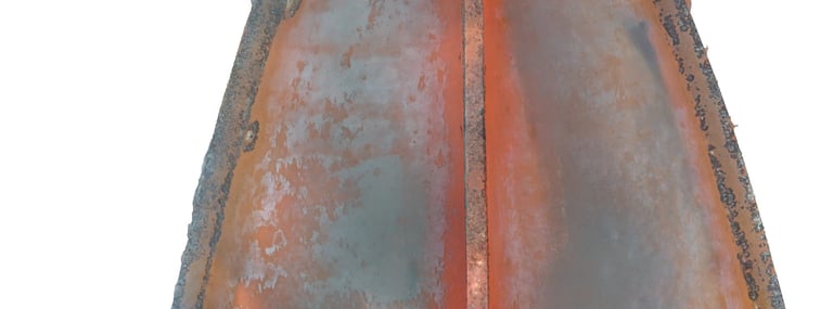
Ship Hull, Propeller & Rudder Inspection - 3D Photogrammetric model
More of our 3D Reconstructions
Address
131 Praxitelous Street, Piraeus 185 32
© Copyright 2024 BMConsulting All Rights Reserved